Preserving & Promoting
Local History, Art, & Culture


Who Ya Gonna Call?
Local Churchyards & Cemeteries: Emergencies & Information
RMWHS offers details on who to contact if you witness a crime, want to report homeless activities, or seek burial records for a local churchyard or cemetery.
FYI - RMWHS has provided a way to reach Leverington Cemetery. Read more ...


WE NEED YOU - Join RMWHS and volunteer!
We have projects big and small -- and you can choose how you help. Please consider joining. We need more hands to help with everything -- including: admin, events, preservation, genealogy & property research, and more.

All Aboard!!!
RMWHS needs images of local ...
-
Trains/Trolleys (inside or out)
-
Tracks/Rails
-
Tickets/Tokens
-
Stations/Stops
-
Maps/Schedules
-
An old family photo of someone taking a train or trolley ride
-
Just about anything!
Please Donate or Lend Your Photos to RMWHS
If you have a photograph, old map, schedule, etc., we'd love to see it. You can donate photos & items or lend them to us and we'll scan and return them to you. Sharing your images with RMWHS will help with historical research, education & promotion, web articles, etc.

Before the train tracks on Cresson were elevated, the tracks crossed Green Lane before continuing toward Main Street.


Donating or lending us your old train/trolley/track/station images can help us provide more items like this!
RMWHS Treasures & Community Projects Presentation
This video shares some of RMWHS new treasures and resources publicly for the first time and current community support efforts.
Presentation includes:
-
A very brief intro about RMWHS
-
Historic books, maps, & deeds from the Leverington Cemetery - include some surprises and a mystery map.
-
Antique and vintage bottles pulled from the Schuylkill as part of the Manayunk Canal Revitalization & Lock 68 rebuild efforts - all have been donated to RMWHS.
-
Historic photos from the Hattal-Taylor VFW Museum that our president is helping to index, scan, restore, and research ... and her request for the public to help with identification of soldiers.
-
And a bit about donations from Andorra (Manatawna) Church and Roxborough Baptist Church.


You can help.
Become a member & volunteer.
$10 students/$20 individuals/$30 families

Donate Old Photos -- Physically or Digitally
Discovering an old photo like this one waiting for us in our email is the delight of an archivist's day -- and even more so when it's this undeniably cute.
RMWHS thanks Ken Gilbert and family for the donation which was added to the RMWHS Archive Image Collection to preserve it for the future.
If you have a photo (or a stack of photos) you think we should see, have, know about, contact us.
We love digital or printed photos as well as slides, negatives, etc. We can scan most images and return the originals if need be.
Local Landmark Featured in Mini Documentary
The Epic Church and it's re-imagining of the former Roxborough Baptist Church building is featured in a new mini documentary by Joe Porter of Innovatory Films and now available for viewing.
The ~5 min film includes interviews with RMWHS's own Linda Marie Bell, who grew up in the Roxborough Baptist church and served on their Board of Trustees, and Epic Church's Pastor Jake Rainwater.
The completed film segment captures a lovely little piece of our local history and evolving community. Visuals include historic photos as well as drone footage outside of the church and cemeteries/neighborhood. And despite the fog — or maybe because of it — some of the aerial shots of the church, cemetery, and neighborhoods have an ethereal quality.
The footage highlights the sanctuary with its gorgeous windows and gracefully curved pews and illustrates the care Epic took to preserve them and incorporate them into the revitalized building.
Screenshots below are property of Innovatory Films.


BELOW - Historic Roxborough Baptist Church images provided for film. Click to expand image.
Watch Film Now >>>>>
RMWHS & the community owe a great thanks to Linda Marie Bell for sharing her time and stories for the making of this film. Through her personal memories, Linda adds a great warmth and brings the history of this beloved landmark to life.
Congratulations to Pastor Jake Rainwater & the Epic Church. And thank you for adding a new chapter to the history of the landmark and our community.
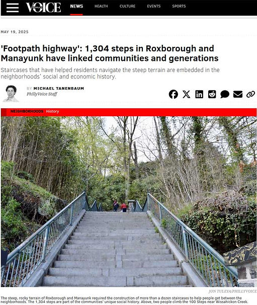
PhillyVoice Interviews RMWHS on 1304 Steps of Roxborough, Manayunk, & Wissahickon
In case you missed it, Michael Tannenbaum of PhillyVoice did a story on the 1304 steps of our area as the rebuild of a local wall and set of steps stirred up their interest. It's a quick read with some great old and new photos ... shines a spotlight on the RMWHS interactive map!
Story & resources it references:
Thanks to RMWHS members Chip Roller and Virginia Buchanan for their participation in the interview.
RMWHS Channel now on YouTube
Original videos created by RMWHS will be posted on YouTube as they become available. There is no schedule. Subscribe to our YouTube Channel to be notified when something new becomes available.
RMWHS only posts what we create.
NOW AVAILABLE: Our first video takes you on a bike ride along the towpath from Shawmont Station to Lock St., featuring historic sites on the Schuylkill River and Manayunk Canal. The ~9 min video provides you with views of the waterways, murals, bridges, historic buildings, and more. RMWHS gets many inquiries from across the U.S. for the history along this 2.4 mile stretch and we thought those that can't visit it in person, might like to see it.


Green Lane Bridge Rehabilitation Project
While construction on the Green Lane Bridge is not scheduled to start until 2030, now is the time to learn about it, ask questions, and provide your input.
Photo by Michael Zosa 2024

DONATIONS REQUESTED
RMWHS preserves local yearbooks, class photos, and school publications within the 21st Ward. Our collection is used for genealogical and local history research ... and we need more to support our efforts.
-
Yearbooks.
-
Photos.
-
Publications.
-
School magazines.
-
Athletic memorbilia
Any School.
Any Year.
Any Condition.
 |  |  |
|---|
Memorials of the 21st Ward
RMWHS has launched a new web section -- Memorials of the 21st Ward -- which provides a listing of the 8 memorials within our area and includes a photo gallery of each.
Each memorial page will be expanded in the months and years to come as images and newspapers clippings (both new and historic) are added. If you would like to contribute an image or information for any of the memorials, please contact us. Also, if we have missed a public memorial within the Roxborough Manayunk Wissahickon area, please let us know.
Each of the memorials is open to the public and all visitors (including service animals) are welcome.
We remind all visitors to be respectful not only to the memorial and grounds, but of the others who may be there remembering loved ones lost, for whom these special places were created to honor.


RMWHS thanks all who have served.
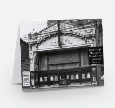
RMWHS Note Cards
To share a bit of local history and raise funds to help support our preservation and outreach activities, RMWHS is offer a set of 8 note cards for $10. The back of each card features facts or info about the photo or its significance.
Each note card set contains 8 envelopes and 2 copies of each of the following 4 images:
-
American Stores Co on Green Lane
-
Empress Theater on Main Street
-
Historic Staircase Between Rox & Mynk
-
Henry Avenue Bridge & Wissahickon Creek
Each note card is approximately 4.25 x 5.5 inches, was printed on a high quality not card stock to ensure a clear image, and is blank inside.
If you are interested in getting note cards, look for the RMWHS tent at the next community event or send us an email if you don't want to wait to get them -- we'll let you know were you can pick them up!